--------
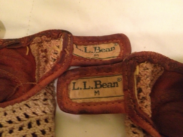
As I started the day with my bike gloves I realized how long I have owned them. I purchased them through mail order from LL Bean in 1981 for my bike trip with Jim Nelson, John Corey and Hugh McLoughlin from Long Island to Cape Cod. I then also used the gloves on my ride with Chris McKenna from Albany to Syracuse in 1986. After my Motobecane was stolen in Philadelphia I did not ride again for many years as children became the priority. I am happy to say though these gloves are still going strong 32 years later.


The day started in Connellsville with the self-serve breakfast - English Muffins with peanut butter. (Sunny-D does not qualify as orange juice, blech.) There wasn't a lot going on in Connellsvile but the city had done a very fine job of clearly marking the path and routes to it.
The plan was for a 61-mile ride from Connellsville to downtown Pittsburgh and much of it along very familiar trails. There are some surprisingly bland sections of the trail that run alongside well worn homes and neighborhoods. But it doesn't take long to catch up with the prettier parts of the Youghiogheny again. (The old Western Maryland tracks upon which much of the GAP is built do not follow a river from Cumberland to Meyersdale. Only there did I start riding along the Casselman River. In Confluence a small creek and the Casselman River meet up with the Yough which then flows north to connect with the Monongahela.)

I saw this sign shortly after leaving Connellsville. It was great to see what I had already accomplished.

There aren't as many historical markers along this section of the trail. A local group, however, placed this memorial and marker to 239 miners.


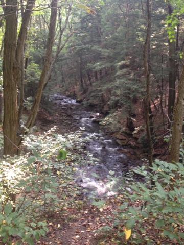
The Yough does certainly have some relaxing spots to sit and enjoy.


But industry had a way of creeping back in - 


At this point I had an eight mile ride home and of course a climb back to Squirrel Hill at the end.

I arrived in West Newton around 10:00 am. I had planned for this to be my lunch stop. Although a bit early I figured that I could find a late breakfast. But it was not to be as nothing was open until 11:00 at the earliest. Thus, out came a protein bar. I did stop, sit and eat and hoped to find something more substantial in Boston, PA (or Little Boston as the sales clerk in Connellsvile called it).
This image below is a good depiction of the elevation changes from Pgh to DC. I'm still aching from the 24-mile climb from Cumberland to the Eastern Continental Divide. The true upside to that three and a half hour climb was that the ride was downhill all the way to Pgh.
As I continued on along the Yough the coal mining business kept getting in the way. This water and red colored rock are a result of acid mine drainage.
http://en.wikipedia.org/wiki/Acid_mine_drainage
I needed to rebalance with a calming Yough photo. This shot is from the path and across someone's backyard. A rather pleasant view from their back porch.
In Boston, PA I was getting closer to home and was hoping for lunch here. I found a pizza shop but without a bike rack. So I continued on and concluded that lunch today would be from my own fridge.
A short ride from Boston is where the Yough meets the Mon in McKeesport. Unfortunately, at this point I was met with rain. For a while I waited it out underneath a parking structure but eventually I slipped on my rain gear and continued through. As is typical of a late day summer rain, it only lasted 15 minutes or so but by this time I had made my way along the trail close to Homestead.
Here on a bridge crossing CSX rail tracks one can see along the Monongahela to the US Steel Edgar Thompson Works in Braddock, PA.
I rode for five days through remote forest and I had to come to a very industrial area of the city along ten sets of tracks to photograph wild turkeys.
As the sun reappeared I removed my rain jacket for the final push. Here in Homestead, PA one can see this historical marker. One hundred years later the steel mill is gone and thousands shop daily at the Waterfront.
The GAP runs along the Waterfront shopping area. This local restaurant helps out the cyclists.
This is the welcome to the City of Pittsburgh along the GAP. (I already have the letter to the mayor written in my head as to how poor a welcome this sign is.)
The GAP ends at Point State Park in downtown Pittsburgh where the three rivers - Ohio, Monongahela and Allegheny converge.
The GAP is exceptionally well signed all the way to Pittsburgh. However, the trail runs along downtown city streets. At the Point with me were four cyclists completing their rides from DC and Cumberland (GAP only). The four of them and I vainly searched for the final mile marker in the park all around the fountain. There was a huge state marker inset in the ground near the actual point. But the GAP marker was not to be found. I finally asked a state employee and he referred me back to the large state marker. The GAP marker is a tiny round inset within the state marker. (The 30-minute ride around Point State Park was somewhat anti-climatic.). But you can see the GAP marker -
And my bike lying on the ground next to it.
Fittingly, as I finished my ride I met a couple taking photographs here to begin their ride to Washington, DC.